Climate compatibility assessment
Assessment methodology
The methodology used to establish the environmental and geographic context and assessments is described for each criterion in Table 3.1 , Table 3.2 , Table 3.3 , Table 3.4 and Table 3.5 .
| Success Factor | Methodology for establishing context |
|---|---|
|
1a. Supports adaptation for and/or resilience to predicted increases in sea levels and storm surge |
Data on the risk of coastal flooding is obtained from the SEPA Coastal Hazard Flood Maps (Version v2.0, issue 11 May 2020, received 25 May 2022) within a 7.5km boundary of the study area. This includes:
|
|
1b. Supports adaptation for and/or resilience to predicted changes in temperatures |
Data on the change in mean annual air temperature, maximum summer air temperature and minimum winter air temperature between 2020-2049 and 2070-2099 (50% probability) is obtained from the MET Office within a 25km boundary of the study area (received 28 March 2022). |
|
1c. Supports adaptation for and/or resilience to predicted increase in likelihood and severity of fluvial and pluvial flooding |
Data on fluvial and pluvial flooding is obtained from the SEPA River Hazard Flood Maps and Surface Water Hazard Maps (Version v2.0, issue 11 May 2020, received 25 May 2022) within a 7.5km boundary of the study area. For both the River Hazard Flood Maps and Surface Water Hazard Maps this includes:
Data is also obtained from the SEPA Future Flood Maps, outlining both Coastal Depth (2080s - 1 in 200-Year +Climate Change) and River Depth (2080s – 1 in 200-Year +Climate Change ) within a 7.5km boundary of the study area. Data on the change in annual precipitation rate is obtained from the MET Office for the period 2020-2049 and 2070-2099 (50% probability) within a 25km boundary of the study area (received 28 March 2022). |
|
1d. Supports adaptation for and/or resilience to predicted increase in likelihood and severity of storms and high winds |
There is no available information for the full study area at the time of assessment to understand the predicted increase in likelihood and severity of storms and high winds. However, road closure data has been provided by BEAR Scotland from their Management of Incidents Database for the time period of 2016-2021. The data on A96 road closure incidents was filtered to show weather-related incident types (flooding; snow; landscaping/fallen/overhanging branches). Once filtered, the incidents were located on the A96 using the section code provided. If any of the incidents were within 7.5km of the study area they were recorded. |
Limitations for establishing assessment for criterion 1
With limited design information available, the assessment narrative is based on the potential impacts and interactions associated with the A96 Full Dualling and all six packages, given the environmental and geographic context. The assessment assumes that the A96 Full Dualling and all six packages are all developed and delivered on the basis that all relevant standards, assessments and guidance will be followed.
| Success Factor | Methodology for establishing context |
|---|---|
|
2a. Supports adaptation for and/or resilience to current and future impacts of climate change within the study area outside of the package boundary |
Data on the geographic and environmental context is outlined above in criterion 1. |
|
2b. Supports the natural environment to adapt for and/or increase resilience to current and predicted future impacts of climate change |
Data on designated habitats is obtained from NatureScot within a 7.5km boundary of the study area. Designated habitats considered include: Sites of Special Scientific Interest (SSSI), Special Protection Areas (SPAs), Special Areas of Conservation (SAC), Wetlands of International Importance (Ramsar), Ancient Woodland Inventory (AWI), Native Woodland Survey for Scotland (NWSS) and Geological Conservation Review Sites. |
Limitations for establishing assessment for criterion 2
With limited design information available, the assessment narrative is based on the potential impacts and interactions associated with the A96 Full Dualling and all six packages, given the environmental and geographic context.
The assessment assumes that the A96 Full Dualling and all six packages are developed and delivered in accordance with all relevant standards, assessments and guidance. The ecosystem services (including supporting, cultural, regulating, and provisioning) provided by the study area were determined through a web search to identify elements including: woodlands (supporting); castles, museums and farm (cultural); peatlands (regulating); and timber merchants (provisioning) .
| Success Factor | Methodology for establishing context |
|---|---|
|
3a. The net change in user carbon emissions sit appropriately within the calculated emissions envelope for Scotland, taking account of changing legislation and targets (including any Climate Change Plan update for Scotland) (assumed current target of 2045) |
The annual emissions envelope for Scotland has been calculated to provide the context or comparator for the scale of the net change in emissions per year. The emissions envelope uses Scotland’s 1990 emissions as the baseline and assumes a percentage reduction from 1990 to zero emissions in 2045. The traffic related carbon emissions are assessed for the years from 2030 to 2045 based on the following rational:
The carbon emissions are calculated from the change in carbon dioxide and nitrogen oxides (converted to CO2e). Data on the net change in road user emissions (year 2030-2045) was obtained from traffic modelling and air quality modelling as part of the A96 corridor review. This data covers annual road user emissions for two scenarios with their inherent variants of transport behaviours – ‘Without Policy Scenario’ and ‘With Policy Scenario’:
|
|
3b. Supports the transition to low carbon modes of transport: transition from higher emissions to lower emissions modes, the modal shift to public transport and the modal shift to active travel for shorter everyday journeys |
Data on active travel networks (National Cycle Network, received 31 May 2022, Core Paths, received 16 May 2019 and active travel hubs, received 11 May 2019) was obtained from Sustrans within a 7.5km boundary of the study area. Data on the number of Electric Vehicle (EV) charging points within a 7.5km boundary of the study area was obtained from Zap Map (received 07 November 2024). This includes:
|
Limitations for establishing assessment criterion 3 success factor 3a.
The modelling and emissions calculation have been produced with the following parameters:
- Zero traffic growth beyond 2045.
- No change in carbon emission rates beyond 2030 and therefore representing a worst-case approach.
- Motorcycles are assumed 0% Zero Emissions Vehicles (electric) in 2030, but 100% in 2045.
- Motorcycles are only 0% Zero Emissions Vehicles for the 2045 ‘With Policy’ scenario (as all other vehicles are ZEV’s), not the ‘Without Policy’ scenario (as only a small proportion are ZEVs)
- No embodied carbon (CO2e) is calculated for battery or fuel cell vehicles due to lack of consistent emission factors for different types of vehicles that can be used.
The calculated emissions envelope assumes zero carbon emissions in 2045, and so 100% reduction against the baseline year of 1990. The percentage reductions in national emissions which provide the annual envelopes are illustrative and not based on forecasts or modelled changes in national emissions for Scotland.
Limitations for establishing assessment for criterion 3 success factor 3b.
With limited design information available, the assessment narrative is based on the potential impacts and interactions associated with the A96 Full Dualling and all six packages, given the environmental and geographic context.
The assessment assumes that the A96 Full Dualling and all six packages are developed and delivered in accordance with all relevant standards, assessments and guidance.
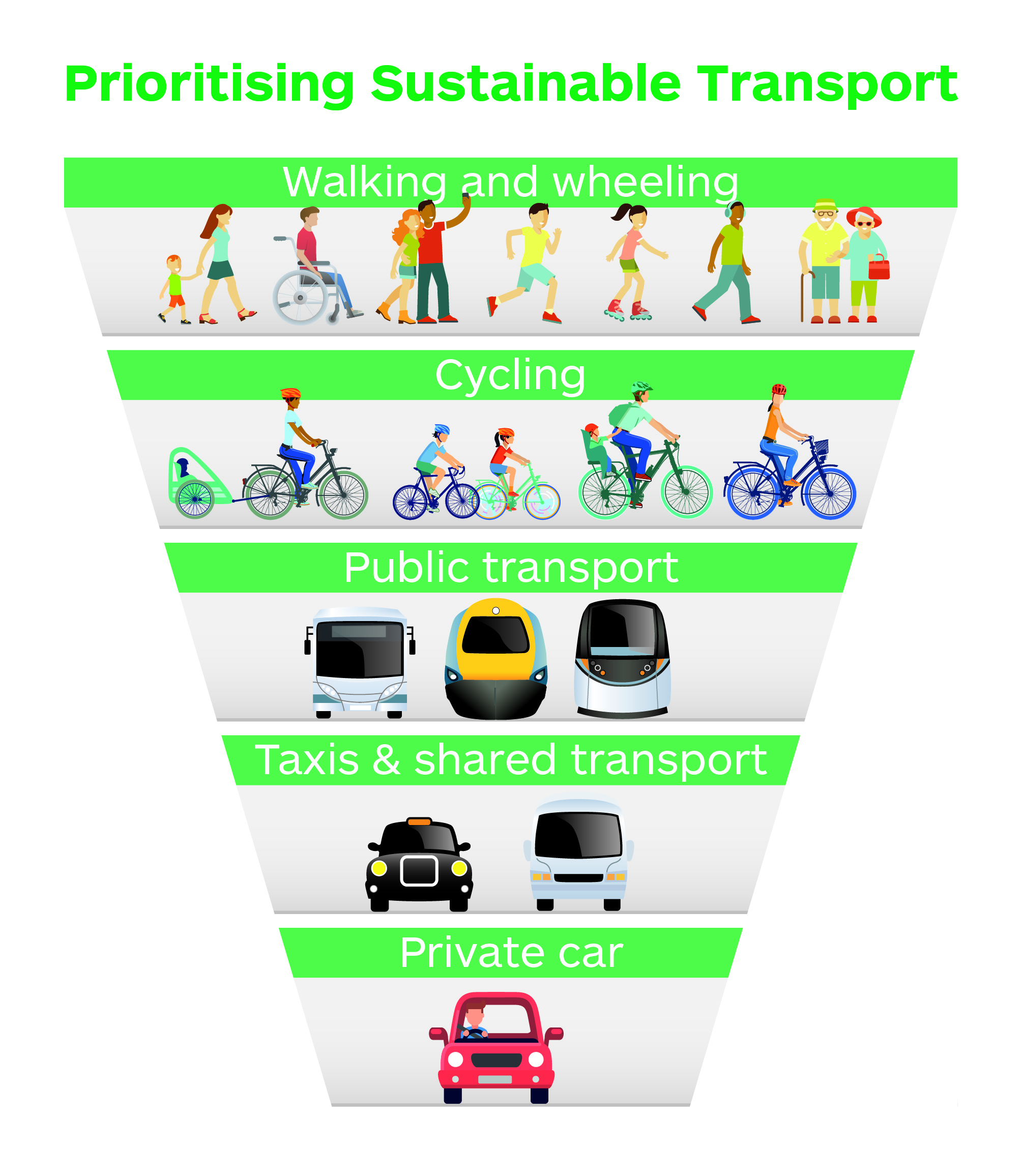
The assessment considers where the A96 Full Dualling and all six packages align with the National Transport Strategy 2 (NTS2) Sustainable Travel Hierarchy, as shown in Figure 3.1.1 . The Sustainable Travel Hierarchy promotes walking, cycling, public transport, taxis and shared transport in preference to single occupancy car use. Considering alignment with the hierarchy helps to develop an understanding of the potential impacts and opportunities each package may have on the shift to low carbon modes of transport.
|
Success Factor |
Methodology for establishing context |
|
4a. Supports transition from higher emission to lower emission materials and technologies during construction, operation, and maintenance |
General UK wide context on carbon emissions/carbon emissions reduction in the built environment is provided from the UK Green Building Council (2021) ; current energy procurement approach for operation of the road network is provided by Transport Scotland. |
Limitations for establishing assessment for criterion 4
With limited design information available, the assessment narrative is based on the potential impacts and interactions associated with the A96 Full Dualling and all six packages, given the environmental and geographic context.
The assessment is high-level and utilises Input-Output tables for high-level carbon assessment of procured goods and services in the absence of detailed information for each of the interventions e.g. Bill of Quantities. The Input-Output tables for high-level carbon assessment of procured goods and services were developed by the Scottish Government and used, in the absence of more reliable carbon emissions factors, to estimate the carbon emission impact from the procurement of purchased goods and services. The Input-Output tables provide tonnes of carbon dioxide equivalent per £1m spend for different industries – for construction this is 280.7 tCO2e/£1m. The assessment assumes that the A96 Full Dualling and all six packages are developed and delivered in accordance with all relevant standards, assessments and guidance.
The calculated carbon emissions are high-level estimates and shown to four significant figures to reflect this.
| Success Factor | Methodology for establishing context |
|---|---|
|
5a. Supports the protection and development of carbon sinks, and takes appropriate measures to maximise carbon sequestration, taking account of wider ecosystem services/natural capital |
Data obtained from NatureScot on designated habitats with the potential for carbon sequestration within a 7.5km boundary of the study area. Designated habitats considered include: Native Woodland Survey for Scotland (NWSS), Ancient Woodland, Local Landscape Areas (LLA) and Peatlands (Class 1, 2 and 3). |
Limitations for establishing assessment for Criterion 5
With limited design information available, the assessment narrative is based on the potential impacts and interactions associated with the A96 Full Dualling and all six packages, given the environmental and geographic context.
The assessment assumes that the A96 Full Dualling and all six packages are developed and delivered in accordance with all relevant standards, assessments and guidance.
Structure of assessment sections
Each assessment section is structured as follows:
- package description;
- geographic and environmental context tables;
- package assessment; and
- recommendations.
Overview of packages assessed
In addition to the A96 Full Dualling Hardmuir to Craibstone, hereon referred to as A96 Full Dualling, six packages of transport options were assessed. The A96 Full Dualling and packages of transport options are described at the start of each assessment chapter in this report. A description of the options found in each package is presented in 0.