A96 Full Dualling
A96 Full Dualling description
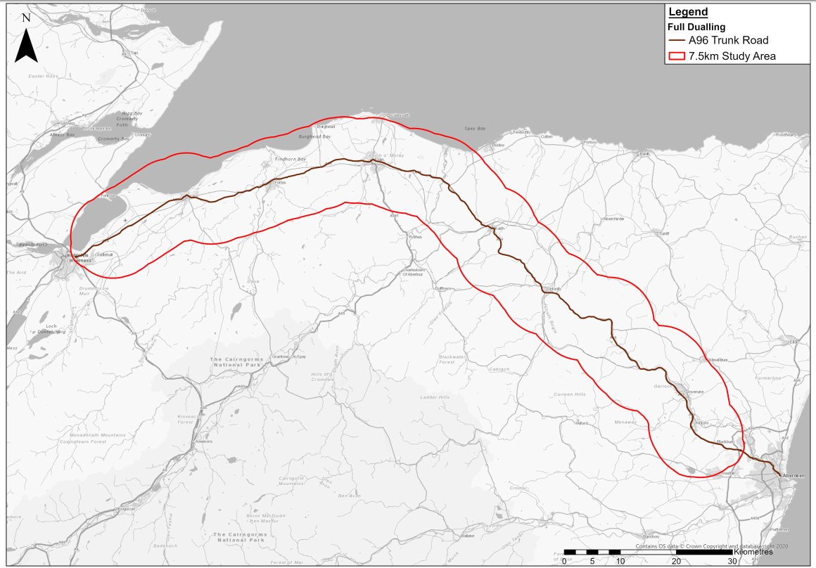
The A96 Full Dualling focuses on improving the trunk road network in the north-east of Scotland to address road safety concerns and provide resilience and reliability improvements for a key connection between Inverness and Aberdeen. The location of the option is illustrated in Figure 4.1.1 .
As part of any potential design for the dual carriageway, it is assumed that new active travel provision would be embedded as part of the dual carriageway as a matter of course. This would likely comprise new active travel provision adjacent to the potential route of any dual carriageway as well as facilities at junctions along any potential route. This provision would be expected to support and enhance the long-distance active travel network in the region and has been considered in the appraisal for A96 Full Dualling. However, it should be noted that any improvements to the active travel network that may be facilitated by bypassing communities have not been considered directly as part of this option.
The A96 is a strategic trunk road which is approximately 155km long and routes from Raigmore Interchange, Inverness in the west to Craibstone Roundabout, Aberdeen in the east. This option considers dualling the full section between Hardmuir (east of Auldearn) and Craibstone Roundabout (west of Aberdeen) which is a total distance of approximately 125km.
It should be noted that the A96 Dualling Inverness to Nairn (including Nairn Bypass) scheme has been excluded from the scope of the A96 Corridor Review as it already has ministerial consent.
The A96 Trunk Road is predominantly single carriageway; however, there are 12 sections which have been upgraded to provide overtaking opportunities via climbing lanes or wide single 2+1 carriageways, equating to approximately 12km of the route. Within the extents being considered as part of this option, the section of the route between Inverurie Roundabout and Craibstone Roundabout is currently dual carriageway, with the majority of junctions being at-grade roundabouts.
This option is designed to deliver economic growth through improving road safety and, as a consequence, improving the resilience and reliability of the route. The option would also be expected to support the shift towards alternative fuelled vehicles, most likely electric vehicles (EVs). For communities and businesses on the corridor, the dualling will provide better connectivity between Inverness and Aberdeen and, in combination with the dualling of the A9 Trunk Road, improve connectivity to the Central Belt.
Criterion 1
Criterion and success factors
- Extent to which the package supports adaptation for and/or resilience to current and predicted future impacts of climate change.
Success factors:
- 1a. Supports adaptation for and/or resilience to predicted increases in sea levels and storm surge.
- 1b. Supports adaptation for and/or resilience to predicted changes in temperatures.
- 1c. Supports adaptation for and/or resilience to predicted increase in likelihood and severity of fluvial and pluvial flooding.
- 1d. Supports adaptation for and/or resilience to predicted increase in likelihood and severity of storms and high winds.
Geographic and environmental context
Table 4.1 , Table 4.2 , Table 4.3 and Table 4.4 outline the geographic and environmental context of the study area against criterion 1 within a 7.5km boundary (unless otherwise stated, for example, when using the MET Office Data) of the full corridor.
|
A96 Full Dualling Study Area |
Geographic and Environmental Context |
|
A96 Full Dualling |
SEPA Coastal Hazard Maps identify a 0.1% chance of coastal flooding each year during a 1 in 1,000-year return period, and a 0.5% chance during a 1 in 200-year period. This risk is confined to the coastal settlements within the wider study area of Findhorn, Burghead and Lossiemouth, although the estuary at Findhorn does allow for a greater extent of coastal flood risk inland. There is also potential coastal flood risk for Nairn, the estuary at Spey Bay and Burghead Bay - though Burghead Bay coastal flooding is largely centred around the beach and does not extend significantly further inland (compared with Findhorn Bay and Spey Bay). |
|
A96 Full Dualling Study Area |
Geographic and Environmental Context |
|
A96 Full Dualling |
Change in mean annual air temperature is predicted to range between +0.87C (2020-2049) and +3.05⁰C (2070-2099) within a geographical boundary of 25km around the corridor (50% probability). Change in maximum summer air temperature is predicted to range between +0.74⁰C (2020-2049) and +3.46⁰C (2070-2099) and change in minimum winter air temperature is predicted to range between +0.83⁰C (2020-2049) and +3.08⁰C (2070-2099) (50% probability). |
| A96 Full Dualling Study Area | Geographic and Environmental Context |
|---|---|
|
A96 Full Dualling |
Fluvial Flooding SEPA Coastal Hazard Maps identify a 10% chance of river flooding each year during a 1 in 10-year return period; 0.5% chance during a 1 in 200-year return period; and 0.1% chance during a 1 in 1,000-year return period. In addition, the geographical area at risk of flooding increases between 10 and 1,000-year return periods, with flood depths ranging between 0.3m and 1.0m. Given the significant number of watercourses, the main risk of flooding within the study area is from river flooding. This risk follows the following watercourses:
The flood mapping illustrates that the River Don poses significant flood risk to roads and settlements between Old Rayne and Dyce, with Kintore and Inverurie at significant risk. Keith however, is deemed to be at low risk. The other main settlements within the corridor of Nairn, Forres, Elgin, Fochabers, Huntly and Blackburn show significant areas of flood risk from various watercourses, including the River Spey and River Deveron. Flood protection schemes have been implemented within the corridor, including at Forres, Elgin, and Huntly, and a flood study for Inverurie and Port Elphinstone is underway. Pluvial Flooding The average change in annual precipitation (50% probability) is predicted to be +4.65% (2020-2049), +4.59% (2040-2069) and +6.27% (2070-2099). Change in summer precipitation rate (50% probability) is predicted to be -0.59% (2020-2049), -7.74% (2040-2069) and -15.28% (2070-2099) while the change in winter precipitation rate (50% probability) is predicted to be +11.88% (2020-2049), +17.06% (2040-2069) and +27.69% (2070-2099). More frequent, high-intensity rainfall will increase the risk of flash flooding from surface water or sewers for inland communities, especially during winter months. |
|
A96 Full Dualling Study Area |
Geographic and Environmental Context |
|
A96 Full Dualling |
There was a total of 11 weather-related incidents (flooding, snow or landscaping/fallen/overhanging branches) between 2016-2021 along the A96 Full Dualling study area. |
A96 Full Dualling criterion 1 assessment
The A96 Full Dualling design being assessed is at an early stage of development with limited design details on which to base an assessment. The assessment is based on potential impacts and interactions the options could have with aspects considered within this criterion.
The geographic and environmental context for the A96 Full Dualling forecast that annual temperatures will increase across the corridor, with drier, warmer summers and wetter, milder winters. This means that the A96 corridor will need to be prepared for a wider range of annual temperatures and need to be resilient to higher peak summer temperatures (which could potentially warp surfaces, impact electronic and electrical equipment and cause heatstroke for operational users or construction workers).
Current standards for designing and constructing transport infrastructure are maintained and updated regularly to account for climate factors. This process should ensure that each option is designed and built to adapt to the predicted future impacts of climate change in and around each of the bypassed towns. Any resulting infrastructure that is built to adapt to future impacts of climate change has the potential to increase the overall resilience of the transport network throughout the A96.
The A96 Full Dualling will be developed in accordance with the Design Manual for Roads and Bridges including DMRB LA 114 Climate standard, which assesses the resilience and adaptation of proposed road infrastructure assets at detailed design stage (DMRB Stage 3). DMRB LA 114 states ''the scoping assessment shall identify whether anticipated changing climate conditions and weather events are likely to have significant adverse effects on the project (or elements of the project) during construction and operation ''.
Examples of potential climate impacts cited in DMRB LA 114 during construction and operations include increased frequency of extreme weather; increased temperatures; increased precipitation; increased sea level rise and wave height; and gales. Therefore, it is assumed that the A96 Full Dualling infrastructure will be designed to ensure resilience against extreme weather and to minimise the potential effects of climate change, to reduce the vulnerability of the infrastructure.
A96 Full Dualling criterion 1 recommendations
All relevant design, construction and maintenance guidance, standards, processes, and assessments should be kept up to date with the latest climate change forecasts and associated best practice and applied to the development of all options.
If the A96 Full Dualling is developed, a climate change vulnerability scoping/assessment exercise should be undertaken, in line with current standards such as DMRB LA 114.
If the A96 Full Dualling is taken forward it is recommended that any potential impacts to the climate resilience of the towns and settlements along the A96 are understood at the earliest design stage and accounted for within the design. Technologies to counteract the impacts of climate change and provide resilience for all relevant elements of the A96 Full Dualling should be considered. The design for each option should embed measures for adaptation against climate-related hazards where practicable, to reduce the significance levels of any adverse impacts.
The vulnerability of the A96 Full Dualling to climate change should be appropriately scoped to understand the potential impacts on the associated assets during construction and operation – for example on electronic equipment; construction workers; end users; site facilities; structures; earthworks; verges; drainage; and construction plant.
Consideration should be made during the site selection process for locations along the A96 that require construction of new facilities or infrastructure, to prioritise locations which are more resilient to the potential effects of climate change. For example, selecting a location for new infrastructure on naturally higher ground levels and building away from coastal areas and/or floodplains that are anticipated to be subject to flooding. Additionally, the drainage capabilities of the infrastructure should be designed to deal with more intense rainfall events and flooding.
Consideration should also be given to including structural adaptation measures, for example, selecting materials that are resistant to the expected extremes of both low and high temperatures; building protective infrastructure such as flood defences in and around the bypassed towns; and using permeable paving surfaces to reduce run-off during heavy rainfalls. Nature-based solutions should also be considered to further enhance natural resilience and adaptation measures.
Finally, the selection of materials used within the construction of the A96 Full Dualling should be based on their resilience to extreme weather, for example, preference should be given to corrosion-resistant materials rather than utilising metals and treating them with a non-corrosive powder coating.
Criterion 2
Criterion and success factor
Criterion 2 is:
- Extent to which the package supports the surrounding area to adapt and/or become more resilient to current and predicted future impacts of climate change.
Success factors:
- 2a. Supports adaptation for and/or resilience to current and future impacts of climate change within the study area outside of the package boundary.
- 2b. Supports the natural environment to adapt for and/or increase resilience to current and predicted future impacts of climate change.
Geographic and environmental context
Table 4.5 and Table 4.6 outline the geographic and environmental context against criterion 2 within a 7.5km boundary (unless otherwise stated, for example, when using the MET Office Data) of the full corridor.
|
A96 Full Dualling Study Area |
Geographic and Environmental Context |
|
A96 Full Dualling |
The geographic and environmental context for the study area are described in the A96 Full Dualling Criterion 1 - extent to which the package supports adaptation and/or resilience to current and predicted future impacts of climate change. |
| A96 Full Dualling Study Area | Geographic and Environmental Context |
|---|---|
|
A96 Full Dualling |
Ecological designations fall either completely or partially within the study area for the A96 Corridor and include: • 43 Sites of Special Scientific Interest (SSSI); • Eight Special Protection Areas (SPA); • Seven Special Areas of Conservation (SAC); • Four Ramsar sites; • One Local Nature Reserves (LNR); • Two Royal Society for the Protection of Birds (RSPB) Reserves; and • 20 Conservation Areas. The number, frequency and density of environmental designations is notably higher at the western end (particularly between Inverness and Huntly). The full extent of the Moray Firth coastline within the study area has environmental protection. |
A96 Full Dualling criterion 2 assessment
The A96 Full Dualling design being assessed is at an early stage of development with limited design details on which to base an assessment. The assessment is based on potential impacts and interactions the options could have with aspects considered within this criterion.
The construction of the A96 Full Dualling could impact the surrounding area’s ability to adapt to climate change. This could be either positive or negative depending on how the options are designed and delivered.
The design and construction of the A96 Full Dualling would be developed in accordance with DMRB. A risk that would need to be managed through design would be the interaction that the option would have with the drainage of the surrounding area. DMRB requires that schemes developed in accordance with the relevant standards should not increase flood risk to the surrounding area. The design should take account of existing risks such as communities that already experience flooding. Development of the option could have a net positive impact on the area’s ability to adapt to climate change if designed and delivered to go beyond mitigating risks and identify and take advantage of potential opportunities. This could include appropriate drainage features and flood defence systems – including outside of the option boundary.
The delivery of the options included in the A96 Full Dualling could positively or negatively impact the ecosystem services provided by the surrounding area, depending on how the options are designed and delivered. The ecosystem services provided by the area surrounding the bypassed towns and which may be impacted by the delivery of the transport options include (but are not limited to):
- Regulating services : such as soil conservation and the carbon sequestration service provided by peatland. For example, between Fochabers and Keith where there are 20 pockets of Class 1 peatland which are nationally important carbon-rich soils, deep peat and priority peatland habitat.
- Supporting services : including nutrient cycling, soil formation and photosynthesis provided by the natural environment along the A96 corridor such as High Wood near Forres; Kirkhill and Birkenhill woods near Elgin; Bennachie Forest near Inverurie; Moray Monster Trails near Fochabers; Crooked Wood near Lhanbryde; and Tyrebagger Hill near Blackburn.
- Provisioning services : fresh water; timber and other forest products processed by companies such as Linnorie Firewood Services and Jewson Huntly timber merchants both in Huntly; Robertson Timber Engineering in Elgin; and Chas Smith Sawmill between Huntly and Keith.
- Cultural services : the recreational and aesthetic sites within the study area including (but not limited to) Garioch Heritage Centre in Inverurie; Huntly Castle; museums including the Moray Motor Museum; the many distilleries in the area including Strathisla Distillery and Strathmill Distillery (both in Keith) and Glen Moray Distillery in Elgin; Gordon Castle Estate near Mosstodloch; Benromach Distillery near Forres; Marshall’s Farm Shop and Forest Farm The Organic Dairy both near Blackburn; Coxton Tower near Lhanbryde; the Coach House Caravan and Campsite and Dunnideer Castle, both between Inverurie and Huntly; and Threaplands Garden Centre between Lhanbryde and Mosstodloch.
The A96 Full Dualling study area includes land designated as environmentally sensitive, including 43 SSSI, seven SAC, eight SPA and 20 Geological Conservation Review Sites, which presents a risk and opportunity regarding their future management. As such, there may be impact on the designated land and its ability to adapt to current and predicted future impacts of climate change.
A96 Full Dualling criterion 2 recommendations
All relevant design, construction and maintenance guidance, standards, processes, and assessments should be kept up to date with the latest climate change forecasts and associated best practice and applied to the development of all options.
The A96 Full Dualling should be designed, constructed and maintained to maximise the opportunities to improve the resilience and adaption of the surrounding area to the future impacts of climate change and local conditions. This could include appropriate drainage features and flood defence systems – including outside of the option boundary.
The A96 Full Dualling should be designed, constructed and maintained to maximise the opportunities to improve the ecosystem services of the surrounding area and the natural environments resilience to the future impacts of climate change. This should include the potential impacts listed in paragraph 4.3.7.
Criterion 3
Criterion and success factor
Criterion 3 is:
- Extent to which the package supports the decarbonisation of the transport network in Scotland, including supporting transition from higher to lower emission modes, and the modal shift to greater public transport and active travel options.
Success factors:
- 3a. The net change in user carbon emissions sit appropriately within the calculated emissions envelope for Scotland, taking account of changing legislation and targets (including any Climate Change Plan update for Scotland) (assumed current target of 2045).
- 3b. Supports the transition to low carbon modes of transport: transition from higher emissions to lower emissions modes, the modal shift to public transport and the modal shift to active travel for shorter everyday journeys.
Geographic and environmental context
Table 4.7 and Table 4.8 outline the geographic and environmental context against criterion 3 within a 7.5km boundary (unless otherwise stated, for example, when using the MET Office Data) of the full corridor.
|
A96 Full Dualling Study Area |
Geographic and Environmental Context |
|
A96 Full Dualling |
No additional context required - the net change calculations are shown in the A96 Full Dualling Criterion 3 Assessment section below (Table 4.9 & Table 4.10). |
| A96 Full Dualling Study Area | Geographic and Environmental Context |
|---|---|
|
A96 Full Dualling |
There are several on and off-road walking and cycling corridors in the study area, many being local networks, alongside a network of long-distance cycle routes that form part of the National Cycle Network (NCN). Though NCN routes are not always adjacent to the A96, they are important long-distance connections between the rural and urban communities within the wider study area. These include:
Long sections of the NCN routes in the study area are on-road and therefore require interactions with traffic. Traffic-free parts of the routes exist in small sections but for longer travel between settlements and towns it is necessary to travel on-road. The entire A96 route is covered by a bus route between Aberdeen and Inverness, with local services available in the larger towns along the route including Elgin and Inverurie. The regional bus network is primarily underpinned by supported public and school transport services run by Stagecoach, as well as First Bus in Aberdeen City, alongside smaller coach operators and local authority run services. Community transport and demand responsive transport services are operated within each of the local authorities although coverage is limited, with membership often required. Transport Accessibility (TRACC) Travel Time Analysis has been used to indicate frequency of bus services along the A96 corridor. This analysis indicates that the smaller towns in the more rural sections of the study area, including Huntly, Keith, and Fochabers have a very infrequent bus service at peak times for commuting to employment or education. Active travel options are available across the study area through both the NCN and Core Path networks. There are more than 320 EV charging points along the entire A96 route, with 73% of those charging points made up of fast charging points. The largest cluster of EV charging points is at the town of Blackburn which has 173 charging points including slow charging, fast charging, rapid charging and ultra-rapid charging points. The EV charging points are largely centred around communities across the A96 route, with very few charging locations across the wider, remoter network. |
A96 Full Dualling criterion 3 assessment
Table 4.9 and Table 4.10 below show the net change in road user emissions with and without the scheme, under both the ‘With Policy’ and ‘Without Policy’ transport behaviour scenarios.
|
Year |
% Emissions reduction from baseline year |
Annual carbon emissions envelope (Mt CO2e) |
Without A96 Full Dualling (Do Nothing) (tCO2e) |
With A96 Full Dualling (Do-Something) (tCO2e) |
Net change (tCO2e) |
Net tCO2e as % of the annual carbon emission envelope |
|
1990 |
Baseline |
75.7 |
N/A |
N/A |
N/A |
N/A |
|
2030 |
75% |
18.93 |
212639.8 |
234954.8 |
22315.0 |
0.118% |
|
2031 |
76.50% |
17.79 |
198463.8 |
219291.2 |
20827.4 |
0.117% |
|
2032 |
78.00% |
16.65 |
184287.8 |
203627.5 |
19339.7 |
0.116% |
|
2033 |
79.50% |
15.52 |
170111.8 |
187963.9 |
17852.0 |
0.115% |
|
2034 |
81.00% |
14.38 |
155935.9 |
172300.2 |
16364.4 |
0.114% |
|
2035 |
82.50% |
13.25 |
141759.9 |
156636.6 |
14876.7 |
0.112% |
|
2036 |
84.00% |
12.11 |
127583.9 |
140972.9 |
13389.0 |
0.111% |
|
2037 |
85.50% |
10.98 |
113407.9 |
125309.2 |
11901.4 |
0.108% |
|
2038 |
87.00% |
9.84 |
99231.9 |
109645.6 |
10413.7 |
0.106% |
|
2039 |
88.50% |
8.71 |
85055.9 |
93981.9 |
8926.0 |
0.103% |
|
2040 |
90% |
7.57 |
70879.9 |
78318.3 |
7438.3 |
0.098% |
|
2041 |
92.00% |
6.06 |
56703.9 |
62654.6 |
5950.7 |
0.098% |
|
2042 |
94.00% |
4.54 |
42528.0 |
46991.0 |
4463.0 |
0.098% |
|
2043 |
96.00% |
3.03 |
28352.0 |
31327.3 |
2975.3 |
0.098% |
|
2044 |
98.00% |
1.51 |
14176.0 |
15663.7 |
1487.7 |
0.098% |
|
2045 |
100% |
0 |
0.0 |
0.0 |
0.0 |
N/A |
|
Year |
% Emissions reduction from baseline year |
Annual carbon emissions envelope (Mt CO2e) |
Without A96 Full Dualling (Do Nothing) (tCO2e) |
With A96 Full Dualling (Do-Something) (tCO2e) |
Net change (tCO2e) |
Net tCO2e as % of the annual carbon emission envelope |
|
1990 |
Baseline |
75.7 |
N/A |
N/A |
N/A |
N/A |
|
2030 |
75% |
18.93 |
318601.7 |
347159.7 |
28558.0 |
0.151% |
|
2031 |
76.50% |
17.79 |
311750.3 |
340270.0 |
28519.7 |
0.160% |
|
2032 |
78.00% |
16.65 |
304898.9 |
333380.2 |
28481.4 |
0.171% |
|
2033 |
79.50% |
15.52 |
298047.4 |
326490.5 |
28443.1 |
0.183% |
|
2034 |
81.00% |
14.38 |
291196.0 |
319600.7 |
28404.7 |
0.197% |
|
2035 |
82.50% |
13.25 |
284344.6 |
312711.0 |
28366.4 |
0.214% |
|
2036 |
84.00% |
12.11 |
277493.2 |
305821.3 |
28328.1 |
0.234% |
|
2037 |
85.50% |
10.98 |
270641.7 |
298931.5 |
28289.8 |
0.258% |
|
2038 |
87.00% |
9.84 |
263790.3 |
292041.8 |
28251.5 |
0.287% |
|
2039 |
88.50% |
8.71 |
256938.9 |
285152.0 |
28213.1 |
0.324% |
|
2040 |
90% |
7.57 |
250087.5 |
278262.3 |
28174.8 |
0.372% |
|
2041 |
92.00% |
6.06 |
243236.0 |
271372.5 |
28136.5 |
0.465% |
|
2042 |
94.00% |
4.54 |
236384.6 |
264482.8 |
28098.2 |
0.619% |
|
2043 |
96.00% |
3.03 |
229533.2 |
257593.0 |
28059.8 |
0.927% |
|
2044 |
98.00% |
1.51 |
222681.8 |
250703.3 |
28021.5 |
1.851% |
|
2045 |
100% |
0 |
215830.3 |
243813.5 |
27983.2 |
N/A |
Figure 4.4.1 below shows the alignment of the A96 Full Dualling with the levels in the Sustainable Travel Hierarchy.
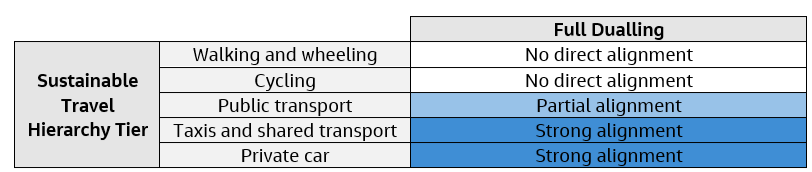
Walking, wheeling and cycling
The A96 Full Dualling alone does not directly align to the top two tiers of the Sustainable Travel Hierarchy. The A96 Full Dualling as described does not included committed improvements to active travel routes along the corridor and so any resulting benefits are not considered within this assessment. However, it is established practice that active travel improvements will be considered and developed where possible during the detailed design of A96 Full Dualling.
Public transport
The A96 Full Dualling as described does not include committed improvements to the provision of public transport along the corridor and so any resulting benefits are not considered within this assessment. It is established practice that public transport infrastructure will be considered and developed where possible during the detailed design of the A96 Full Dualling and, if included, the provision of any public transport infrastructure could support the decarbonisation of Scotland’s transport network through enabling modal shift.
Taxis, shared transport and private car
Full dualling of the A96 corridor will be utilised by modes of transport that sit lower on the Sustainable Travel Hierarchy (private cars, vans, HGVs and shared transport such as taxis). As the provision of the A96 Full Dualling may improve attractiveness of the A96 for private vehicles this may have a counter effect on modal shift.
A96 Full Dualling criterion 3 recommendations
All relevant design, construction and maintenance guidance, standards, processes, and assessments should be kept up to date with the latest climate change forecasts and associated best practice and applied to the development of all options.
The A96 Full Dualling should be designed to maximise alignment with the Sustainable Travel Hierarchy and careful consideration should be given to how the options can work together to optimise the lowest carbon option, for example, for different journeys and shorter routes. The A96 Full Dualling would be designed to DMRB standards. As such, the design will be obligated to consider the provision of facilities for non-motorised users of the A96 corridor. The A96 Full Dualling should be designed to maximise associated active travel; and opportunities for public transport, and therefore, could provide potentially beneficial opportunities to encourage local lower emission modes of transport.
Interventions along the corridor should include 'electrifying' the A96 corridor wherever practical to encourage the change from traditional engine to electric vehicles, where private car use will still be high. The electrification of the corridor should include the distribution of electric and hydrogen-based fuel sources in addition to other alternative fuels such as HVO and Ammonia. The dispensaries should be placed strategically along the A96 so that they are highly accessible to both road users and rural local communities. Consideration should also be given to demountable and mobile infrastructure.
Public transport, which sits higher in the Sustainable Travel Hierarchy, should be encouraged/incentivised for the journeys of locals and visitors within the corridor. Investment into low carbon/zero carbon technologies should be explored - such as producing new fleets of electric buses for all routes within the corridor.
Criterion 4
Criterion and success factor
Criterion 4 is:
- Extent to which the package supports the decarbonisation of the construction sector in Scotland and maximises reduction in whole life carbon emissions.
Success factor:
- 4a. Supports transition from higher emission to lower emission materials and technologies during construction, operation, and maintenance.
Geographic and environmental context
Table 4.11 outlines the geographic and environmental context against criterion 4 within a 7.5km boundary (unless otherwise stated, for example, when using the MET Office Data) of the full corridor.
|
A96 Full Dualling Study Area |
Geographic and Environmental Context |
|
A96 Full Dualling |
UK Built Environment is responsible for 25% of total UK carbon emissions including buildings and infrastructure ( UK Green Building Council, 2021 ). In relation to operation of their network Transport Scotland, as part of the Scottish Government, use renewable or zero carbon electricity tariffs for the electricity used to power the road network (such as for the use in lighting). |
A96 Full Dualling criterion 4 assessment
The A96 Full Dualling design being assessed is at an early stage of development with limited design details on which to base an assessment. The assessment is based on potential impacts and interactions the options could have with aspects considered within this criterion.
Since there are limited design details, the carbon emissions impact is estimated from the capital cost forecast by applying the Scottish Government ‘Supply, Use and Input-Output Tables’ figure for construction. This provides an estimate of between 701,700tCO 2 e and 1,403,000tCO 2 e for the capital stage carbon emissions impact.
The construction stage carbon emissions will vary between the elements of the A96 Full Dualling. The variability is likely to depend on the level of new infrastructure required to implement the elements – with the greater the level of construction resulting in greater levels of associated carbon emissions.
The A96 Full Dualling as described makes no commitments to how the carbon emissions impact from construction, maintenance and operation would be minimised and so any resulting benefits or carbon reduction measures cannot be specifically considered within this assessment.
The operational element of the carbon emissions impact is reduced in part through the use of renewable/zero carbon electricity tariffs, if that approach is continued.
If the A96 Full Dualling is developed the proposed design alignment would be subject to relevant standards and assessment procedures for the type of transport infrastructure. For example, for road development this would include the Design Manual for Roads and Bridges. Where the latest version of the DMRB climate change assessment standard (LA 114) is applied it requires the assessment of carbon emissions at detailed design stage.
A96 Full Dualling criterion 4 recommendations
All relevant design, construction and maintenance guidance, standards, processes, and assessments should be kept up to date with the latest best practice on carbon emission reductions and applied to the development of all options.
If the A96 Full Dualling was taken forward there would be an opportunity as a major infrastructure project in Scotland to strongly support decarbonisation of the construction sector. Application of PAS2080: Carbon Management in Buildings and Infrastructure to all schemes and all suppliers will help to systematically address whole life carbon emissions. This should include stretching carbon emissions reduction targets for suppliers, and consideration of carbon neutral standards (such as PAS 2060 – Carbon Neutrality Standard and Certification) for any suppliers managing the network beyond 2045.
The impact of the A96 Full Dualling on carbon emissions will depend on the methods used during construction. It is therefore recommended that innovative techniques and technologies are used where relevant to reduce emissions. These should be focused on optimising the design to build less and to consume less carbon intensive materials (such as asphalt, concrete and steel). This could include lower temperature mixes for asphalt, concrete with high cement replacement, and steel with high recycled content.
During construction opportunities to reduce carbon emissions should be maximised such as local sourcing, construction and logistics efficiencies, and alternative modes of transport – for example rail rather than road, low emission vehicles, and low carbon fuels.
With regards maintenance, more resilient technology could be installed in the first instance to withstand climatic factors, subsequently making the option more resilient and requiring less maintenance. As techniques and technologies improve, it is recommended that these are adopted at the earliest possible stage, subject to a cost/benefit analysis being undertaken.
The principles of the circular economy should be applied during design, construction, and maintenance. For example, material reduction and reuse should be prioritised to comply with the waste management hierarchy, and opportunities should be sought to recondition and use existing transport infrastructure where appropriate.
Criterion 5
Criterion and success factor
Criterion 5 is:
- Extent to which land use change associated with the package mitigates carbon emissions and contributes to carbon storage and sequestration.
Success factor:
- 5a. Supports the protection and development of carbon sinks, and takes appropriate measures to maximise carbon sequestration, taking account of wider ecosystem services/natural capital.
Geographic and environmental context
Table 4.12 outlines the geographic and environmental context against criterion 5 within a 7.5km boundary (unless otherwise stated, for example, when using the MET Office Data) of the full corridor.
|
A96 Full Dualling Study Area |
Geographic and Environmental Context |
|
A96 Full Dualling |
There are several pockets of peatland across the study area:
Within the A96 Study Corridor, there are approximately 32,400 hectares of Ancient Woodland (AWI) (919 counts) and 12,150 hectares of woodland recorded in the Native Woodland of Scotland Survey (NWSS) (3,325 counts). |
A96 Full Dualling criterion 5 assessment
The A96 Full Dualling design being assessed is at an early stage of development with limited design details on which to base an assessment. The assessment is based on potential impacts and interactions the options could have with aspects considered within this criterion.
The A96 Full Dualling option is solely infrastructure-led and does not explicitly include the provision of public realm improvements to green space or blue or green infrastructure assets. Therefore, it is not possible to confirm if the A96 Full Dualling would have a positive impact on land use change, carbon storage and sequestration
The option has the potential for negative environmental effects on the storage and sequestration of carbon within natural ecosystems. The scale of the effects would be subject to detailed design and the route being determined. Therefore, at this stage the extent of effects is uncertain.
If the scheme is developed, it would be subject to relevant standards and assessment procedures. If the latest DMRB climate change assessment standard was applied (DMRB LA114) this would assess the carbon emissions changes at detailed design stage.
The study area includes land designated as environmentally sensitive which present a risk and opportunity to be managed in terms of how they are impacted on/or supported in terms of their ability to sequester and store carbon.
A96 Full Dualling criterion 5 recommendations
All relevant design, construction and maintenance guidance, standards, processes, and assessments should be kept up to date with the latest climate change forecasts and associated best practice and applied to the development of all options.
If the A96 Full Dualling is taken forward it could present opportunities to improve the ecosystem services provided (including carbon sequestration) through positive land use change.
Existing carbon sinks should be enhanced wherever possible, to increase potential carbon sequestration as an integral part of the schemes, particularly relating to peatland restoration and wetland enhancement.
While the exact route is to be determine during later stages of design, it is anticipated the scheme would be sited as far as possible from environmentally sensitive areas including woodland and peatland. This should not exclude the opportunity to consider the wider corridor within any works to seek to improve degraded peatland to improve carbon sequestration within the corridor. This would in turn have a positive effect in reducing the net carbon emissions associated with the scheme. Woodland planting, in areas that are not currently being used for grazing or crops, could also have positive effects on biodiversity and provide additional sequestration.